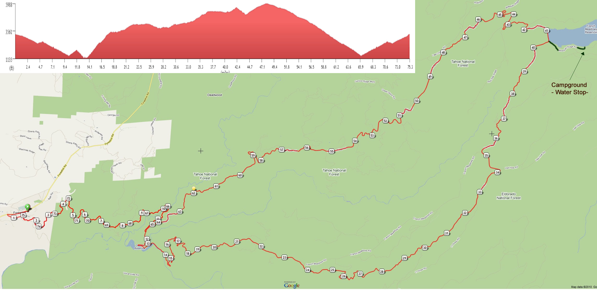
This loop out of Foresthill is one of the most scenic and challenging rides in the area. The challenges include severe climbing, long distances without available water, and extreme heat climbing out of a canyon in the afternoon. It is recommended you take all precautions to ensure you have adequate water for this venture.
The ride begins with a 10 mile drop down the canyon to the Circle Bridge. Take an extra water bottle with you and hide it somewhere nearby for the return trip. Continue riding along Mosquito Ridge Rd until you see the sign to Oxbow Reservoir where another long descent awaits. At mile 13.8, the serious climbing up the Corkscrew begins for 4.5 miles. At mile 33.7, a spring (pipe with water flowing out) on the left side of the road is available to refill your bottles. When you arrive at French Meadows Dam, you can optionally ride along the right side of the lake to a campground for water and restrooms. This is an additional three mile out and back to the loop. On the ride back to the Circle Bridge, enjoy a scenic 18 mile stretch of downhill. The Big Trees Grove Park may have water available. At Circle Bridge, pick up your stashed water for the long nine mile climb back up. A detour on Soap St. provides an alternative route through Foresthill back to the parking lot at the ride start.
| Miles | Type | Notes |
| 0 | START | Foresthill Elementary School - head downhill on Main St |
| 0.6 | STRAIGHT | STOP SIGN - merge with Foresthill Rd |
| 0.7 | LEFT | Left onto MOSQUITO RIDGE ROAD |
| 10.2 | WATER | CIRCLE BRIDGE - leave extra water for return climb to Foresthill |
| 11.7 | RIGHT | Right onto BLACKSMITH FLAT RD - start decent to Oxbow Reservoir |
| 12.5 | LEFT | Stay left at "T" intersection |
| 13.1 | VALLEY | RESTROOMS at Ralston Picnic Area |
| 13.8 | Hors category | OXBOW POWERHOUSE - start climb of Ralston Ridge - AKA: Corkscrew |
| 18.3 | SUMMIT | Top of Ralston Ridge Climb - 4.5 miles/2600' |
| 23.6 | RIGHT | Stay right at paved fork in road |
| 29.5 | LEFT | Stay left (right is Ramsey's Crossing Rd -which leads to Georgetown) |
| 32.5 | STRAIGHT | merges with ELEVEN PINES RD |
| 33.7 | WATER | H2O - Spring is on the left side |
| 34.2 | LEFT | junction with Hell Hole Rd |
| 40.6 | LEFT | FRENCH MEADOWS DAM - left onto MOSQUITO RIDGE RD |
| 40.6 | Optional | 3 mile out & back to campground for water/rest rooms |
| 42.2 | SUMMIT | Red Star Ridge |
| 44 | VALLEY | Duncan Creek |
| 47.8 | SUMMIT | junction with Robinson Flat Rd(dirt)- elevation 5988' - start 18 mile descent |
| 51.3 | STRAIGHT | Big Trees Grove Park - (one miles distance from Mosquito Rd) |
| 55.2 | STRAIGHT | junction with Interbay Rd |
| 58.8 | STRAIGHT | viewpoint - Mile 17 overlook |
| 62 | STRAIGHT | The Mosquito Narrows - cliff area |
| 66.1 | WATER | CIRCLE BRIDGE -pick-up stashed water for return climb to Foresthill |
| 74.8 | RIGHT | Slight right at SOAP ST. - gear down |
| 75.1 | RIGHT | turn right on MAIN ST |
| 75.3 | END | sprint to school parking lot |
